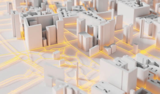
Saudi Arabia’s $500 billion, smart mega-city, NEOM, is breaking ground on the unspoilt coastline of the Red Sea, setting in motion a chain-reaction of construction projects creating a city where robotics is revolutionizing everything and outnumbering people, and self-driving cars are the norm. NEOM will be Saudi’s first truly AI-powered, 5G-ready city, with autonomous transport – the playground for future smart city innovations. This futuristic city is made possible through modern, high-tech geospatial imaging.
To build NEOM on untouched land, planners need measurements down to the last millimetre: elaborate 3D models of each planned building, each piece of infrastructure, each service will be conceived before any dirt is turned. Without it, the city is likely to face costly delays and construction fails, such as the drainage issues that already plague some of Saudi’s older cities.
“All of the services are pre-planned in 3D virtual digital twins: traditional electrical, water, stormwater and transportation, along with 4th Industrial Revolution smart infrastructure extending to wireless network coverage modelling. Only once all of these elements are combined within 3D environments, can we ensure each part does not conflict in the 3D space,” Reece van Buren, Technical Sales Director at Digital Surveying, and Executive of the South Africa Geophysical Association told LEAP.
Gone are the days of manually surveying a construction site only to find your measurements were out, or the underlying bedrock is unstable. Geospatial imaging has brought about a revolution in data accuracy and availability, enabling planning for a multitude of construction applications at scales previously unimaginable.
Geospatial imaging is one of several space and satellite topics on display at our mega-tech event in February 2022. While discussing the future of technology, our mega-tech event will see the best and brightest minds in the Geospatial Imaging sector bring their developments and smart cities technologies to the attention of the world.
The lifecycle of a modern construction project
As cities grow into previously undeveloped areas or start from scratch, the first infrastructure to be put in place is underground, and out of sight. Essential underground municipal services must be put in place to cater for the inevitable growth, driven by increasing population pressure. The next step is to construct hard surfaces, these include roads, culverts, sidewalks, parking areas – these all impact directly upon rainwater drainage management – the more hard surfaces, the more they impact water run-off.
“Climate change is real; water drainage planning is fundamental which will be at the core of Saudi’s smart city planning. If one doesn’t get that right, there will be problems down the line, it’s much harder to fix when you have infrastructure on-site,” says Van Buren.
The initial geospatial imagery from satellite platforms is used to characterise topsoil (outcrop), down to the minerals in that soil layer. These directly impact the geomechanical properties of that strata and have a bearing on the geohazard, which affects how you build digital cities.
Geospatial data becomes an asset and will continue to be used as Saudi Arabia’s smart cities grow. This data is used for applications including change detection, vegetation and transport route management, parks and urban recreational space planning, light and sound pollution, connectivity modelling within urban planning, and so much more.
“Geospatial Imaging is changing the way Saudi builds and expands its cities. By using the technology from the beginning of the planning process, we are on track to build digital cities of the future that enthral its citizens and operate seamlessly from the day they break ground. At LEAP we plan to expand on the knowledge base we already have in the geospatial sector, and see where this technology can take us in our journey to a smart Saudi Arabia,” explains a Ministry of Communications and IT spokesperson.
Catch the Smart City Orbital Talks, day one to three for more in-depth insight into the development of smart cities and how cities such as NEOM will revolutionise the way we, as Saudi citizens work, play, travel, and interact. Building a 5G-enabled city is closely linked to the Internet of Things which is not only making our lives easier and safer, but is also helping in the creation of cognitive cities.
Don’t skip geospatial imaging
Without using geospatial imaging for smart city planning; opportunities will be missed, and the ergonomics of spaces will fall short of contemporary urbanites’ expectations. Construction costs will also be substantially higher due to infrastructure conflicts, geohazards, poor change management planning and more.
Your first challenge is geology, the topography and the nature of the subsurface. What soil and what bedrock underlie the construction area, is it geotechnically and structurally stable and are any extraordinary measures required to start construction?
The second challenge is stormwater, which can result in flooded cities in the future. With climate change impacting sea level, if these changes have not been factored into the construction, substantial infrastructure may either be lost or massively costly engineering required to protect these.
Other challenges include access to power, with increasing demand on smart cities technologies, and connected devices, and the transition to low carbon footprint power sources such as solar. Saudi’s 5g smart cities will need to ensure that sunlight access is democratised through careful geospatial planning, easily achieved in their digital twin environments.
“The [solar incidence] impact of any envisaged infrastructure within an urban space can be assessed within the smart city digital twin – not to mention the impact of natural solar illumination on mood and general mental wellbeing. Futuristic city inhabitants of tomorrow will not want sunlight at a premium,” explains van Buren.
As the saying goes, ‘By failing to prepare, you are preparing to fail’, and this runs just as true for construction, as it does for life.


